toplogo
Connexion

Seismic Evidence Reveals Complex Fault Network at Subduction Zones


Concepts de base
Seismological data shows that the subduction zone seismogenic interface is composed of a network of simultaneously active, metres-thick faults, which influences afterslip propagation and earthquake rupture dynamics.
Résumé

The content provides insights into the detailed structure of subduction zone seismogenic interfaces, which generate the largest earthquakes on Earth. Geological studies have characterized the interface as a 100 m–1 km thick zone with deformation occurring on metre-scale faults. In contrast, seismological studies often image the interface as a kilometres-wide band of seismicity.

The study uses a high-resolution 3D velocity model and dense earthquake relocations in Ecuador to obtain a detailed image of seismicity at the subduction interface. The results show that earthquakes sometimes occur on a single plane, but often on several simultaneously active, metres-thick subparallel fault planes within the interface zone. This geometrical complexity affects the propagation of afterslip, demonstrating the influence of fault continuity and structure on slip at the seismogenic interface.

The findings provide important insights that can help create more realistic models of earthquake rupture, aseismic slip, and earthquake hazard in subduction zones. The multifault network structure revealed by seismological data contrasts with the simpler geological models, highlighting the value of integrating different observational approaches to understand the complex deformation processes at subduction interfaces.

edit_icon

Personnaliser le résumé

edit_icon

Réécrire avec l'IA

edit_icon

Générer des citations

translate_icon

Traduire la source

visual_icon

Générer une carte mentale

visit_icon

Voir la source

Stats
Earthquakes occur sometimes on a single plane and sometimes on several metres-thick simultaneously active subparallel planes within the plate interface zone. The study used a local three-dimensional velocity model and observations of more than 1,500 double-difference relocated earthquakes in Ecuador.
Citations
"Geological studies of fossil subduction zones characterize the seismogenic interface as a 100 m–1 km thick zone1,2,3 in which deformation occurs mostly on metres-thick faults1,3,4,5,6." "Conversely, seismological studies, with their larger spatial coverage and temporal resolution but lower spatial resolution, often image the seismogenic interface as a kilometres-wide band of seismicity7."

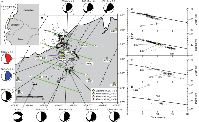
Questions plus approfondies

How do the fault network structures identified in this study vary across different subduction zone settings, and what are the implications for regional earthquake and tsunami hazard assessments?

The fault network structures identified in this study exhibit variability across different subduction zone settings due to the complex nature of subduction interfaces. In some regions, the seismicity is concentrated on a single plane within the plate interface zone, while in others, multiple subparallel planes of seismic activity are observed simultaneously. This variation in fault structures has significant implications for regional earthquake and tsunami hazard assessments. Understanding the detailed fault architecture can help in assessing the potential for earthquake rupture propagation and the generation of tsunamis. Regions with multiple active fault planes may experience more complex earthquake behavior, leading to larger magnitudes and increased seismic hazard. Additionally, the presence of these multifault networks can influence the distribution of afterslip and aftershocks, further impacting regional seismic risk assessments.

What are the potential limitations of the seismological approach used in this study, and how could the integration of other geophysical and geological data help provide a more comprehensive understanding of subduction zone fault architecture?

The seismological approach used in this study, while providing valuable insights into the seismicity of subduction zones, has certain limitations. One limitation is the lower spatial resolution of seismic data, which may not capture the full extent of fault structures at the subduction interface. Additionally, seismic data alone may not provide information on the mechanical properties of faults, such as their frictional behavior or locking depth. To overcome these limitations, the integration of other geophysical and geological data is essential for a more comprehensive understanding of subduction zone fault architecture. For example, geodetic data from GPS measurements can help constrain the deformation patterns and slip rates along faults. Geological studies, including trench observations and paleoseismic analysis, can provide insights into the long-term behavior of faults and the recurrence of large earthquakes. By combining seismological data with other geophysical and geological datasets, researchers can create a more holistic view of subduction zone fault architecture, improving our understanding of earthquake processes and hazard assessment.

What insights from the multifault network structure could be leveraged to improve numerical models of earthquake rupture propagation and aseismic slip transients in subduction zones?

The insights gained from the multifault network structure identified in this study can be leveraged to enhance numerical models of earthquake rupture propagation and aseismic slip transients in subduction zones. By incorporating the detailed fault geometry and complexity observed in the seismicity data, numerical models can better simulate the heterogeneous nature of fault slip during earthquakes. Understanding how multiple subparallel fault planes interact and influence each other during seismic events can improve the accuracy of rupture propagation models. Additionally, the influence of fault continuity and structure on afterslip propagation highlighted in this study can be integrated into numerical simulations to better capture post-seismic deformation patterns. By incorporating these insights into numerical models, researchers can develop more realistic representations of earthquake processes, aseismic slip transients, and earthquake hazard in subduction zones, ultimately improving our ability to assess and mitigate seismic risk in these tectonically active regions.
0
star